 Amersham
For many centuries, Amersham did not change a great deal.
However, with the coming of the Metropolitan Railway in 1892, Amersham
started to change with the creation of Amersham on the Hill.
Over recent years, there have been many changes. Much infilling has taken
place.
On this page are some examples of how some of the area has changed. If
anyone has any other old photographs which can be compared with today, we
would be pleased to receive them. Please email
the web master.
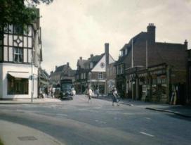
Sycamore Road   Left, Sycamore Road early 1960's. The Regent Cinema dominates, on the left are trees in front of the then Free Church. In the centre, the same location in 2006. The Regent Cinema was demolished in the 1960's and was replaced by a supermarket, "The Maypole" which later became Liptons, then Iceland. In the 1980's the shops next to it were replaced with more modern buildings. In 2018 the site was cleared to make way for Regent Place. The right hand photograph shows Regent Place on the same site in 2019, comprising shops on the ground floor and flats above. |
|
   The Oakfield Corner end of Sycamore Road has not changed much over the years. The left photograph is from the 1950's, the next 1960's and the third 1990's. With the exception of the road markings and shop fronts, the view is much the same. |
|
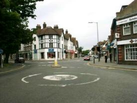
  Sycamore Corner has changed quite a bit. The photograph on the left is from the 1950's, on the right 2000. The parade of shops on the north west side remains, but a new 1970's block has been built to the right along Rickmansworth Road. On the other side of the road the numerous small shops and houses have been replaced with a 1960's development of shops, offices and flats stretching along Sycamore Road and Woodside Road. |
|
Hill Avenue 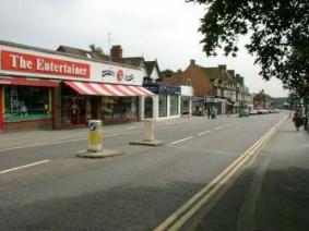  On the left Hill Avenue in the
1950's. At this time there were still quite a few houses
along the road and a tree on the left. By the 2000's, the
road was all shops and offices with The Entertainer toy shop at
the Oakfield Corner end. With The Entertainer having moved
around the corner onto Sycamore Road, the building was rebuilt in
2015 with flats above a new bar / cafe called Metro Lounge.
|
|
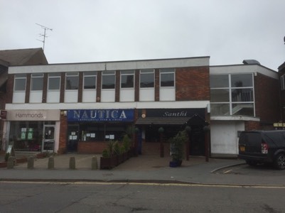 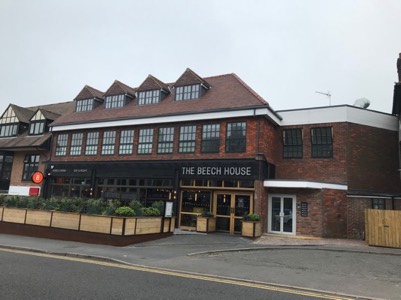 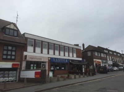 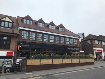 The photographs on the left above
show part of Hill Avenue in 2015 and those on the right the same
site redeveloped in 2018. The site is deceptively large and
extends to also face Chesham Road. The original 1970's
development replaced houses originally built in the 1920's /
30's. When opened in the 1970's the block included
Amersham's first wine bar called "Annies" along with "Tuck In" the
fish and chip shop (later Nautica) and a TV / Hi Fi / Record shop
called Audio Visual Systems. The redeveloped site I believe
looks nicer and includes more flats above.
|
|
Chestnut Lane  The photograph above shows the Red Lion pub on Chestnut Lane. One Friday night in 2012 the pub suddenly closed and was quickly partly demolished. After a dispute the developers replaced the pub with houses, one of which can be seen in the right hand photograph above. |
|
Around Amersham Station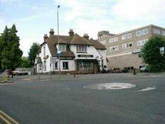 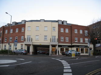 Left, The Iron Horse, formerly the Station Hotel. One of the first buildings to be built after the opening of the station in 1892, it was refurbished into the pub above. The right photograph shows the building which replaced it when the pub suddenly closed in 2004. Following a planning appeal, the pub was demolished and replaced by flats with a restaurant on the ground floor. |
|
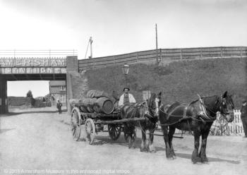  The top of Station Road has changed quite a lot. The 1890's photograph on the left shows the original railway bridge with the Station Hotel visible beyond. The photograph on the right shows the new railway bridge built in 1960 which includes an extra track necessary when Amersham became the terminus of the Metropolitan Line. |
|
  Photographs courtesy of Ken's Beijing Chinese Restaurant Just below the railway bridge at the top of Station Road saw the first commercial development in Amersham on the Hill. The original plan was for Station Road to become the main shopping street for Amersham on the Hill, but that never happened, leaving just a few shops at the top. Station Parade was designed by London architect, John Kennard. The left hand photograph is from 1905, the right hand photograph from 2007. Although the modern shop fronts have spoiled the look of the building today, it can still be seen to be a handsome construction. The 1905 photograph in many ways is very "London" in its look. The building used to contain Weatherall the Medical Eye Centre and Swindles (newsagents). On the right the auction rooms now occupy part of the building. The auction rooms are housed in an interesting building. Originally it was the Bijou Hall, then the Playbox Cinema. It was then converted to the Play House Theatre which opened in 1936, with seating for 240. The repertory company had moved from Chesham Bois (where they had used a barn on what is now the Beacon School site) and proved quite popular for a few years. Dirk Bogarde made his early appearances at the theatre, but after the war it could not compete with the changing tastes of the time (television?) and by 1956 the local estate agents had purchased the building. |
|
  Left, a view of buildings towards the top of Station Road taken in the 1930's. Photograph courtesy of the late Peggy Bonner nee Gilbert-Brown, who lived in "Woodcot" in the 1930's. Right, the same buildings in 2006. |
|
   On the left, the view of the station from the 1970's. The remains of the goods yard are still visible along with the goods shed. The two right views from 2006 show how the trees have grown up to hide not only housing, but the multi-storey car park and the office block. |
|
  The above photograph on the left shows the station goods shed in 1981 not long before demolition. The goods yard had closed in the 1960's, but the land around the shed became a coal yard and car park. On the right, this 2006 view of the same location showed the then NHBC offices and multi-storey car park. The NHBC offices have since been demolished and replaced. CLICK HERE to see details of the change from the NHBC building to the Decimal Place building   The photograph on the left shows the original Amersham station multi-storey car park opened in the 1980's. It replaced the original station car park, which was an open air surface car park on the other side of the railway, accessed via a foot bridge. After the new car park opened, houses were built on the old car park. In November 2019, an extension to the car park was opened, shown on the right, a truly ugly building, which appears to make no effort to blend in! |
|
Chesham Road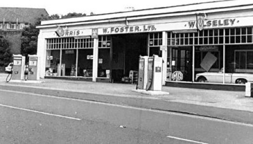 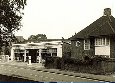 The above photographs, courtesy of Mike Powdrill, show Fosters Garage on Chesham Road in 1968. This is opposite the entrance to Dr. Challoners Grammar School. This site was redeveloped in the 1970's and joined the site which fronted onto Hill Avenue, forming a garage on the ground floor with flats above (shops on ground floor and flats above on Hill Avenue). 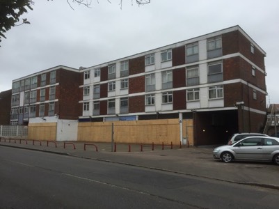 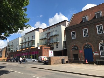 The above photograph on the left shows the Chesham Road site in 2015 just before it was redeveloped, with the new building, now with Majestic Wine on the ground floor, opening in 2018.   The rather poor quality photograph above on the left shows the Burmah petrol station on Chesham Road, close to the Boot & Slipper pub, in the 1990's. There had been a garage on this site for many years and from the 1980's the old garage workshops were converted into the Triangle Snooker club. The photograph above on the right is the same location in 2020 showing the car wash where the petrol station used to be.   Looking the other way on Chesham Road, there used to be a few white houses and at one time a shop. These were demolished and replaced by a larger number of dwellings as seen in the view from 2020 on the right.   For many years, at the junction of Chesham Road and South Road was Guido's Restaurant. Before it was a restaurant I believe it was used as a bridge club. The above left photograph shows the restaurant. In 2016, the family run restaurant closed and was replaced by new houses as shown in the photograph above right. |
|
Woodside Road  At the junction of Woodside Road and Chiltern Avenue was a large building, which for many years was Ward and Medleys, a furniture repository. The building was then used by Freezer Fare, which was one of the first retailers to sell frozen food in both single items and bulk items. The photograph above on the left was taken by Gill Bilski during the carnival in 1985. The building was demolished in the 1990's and replaced by an office block, which had many occupants and in 2018/9 was converted into flats, called Medley Court. |
|
   Not a huge change, but when the car park with a ramp to an upper level was built in the early 1970's behind the then new Budgen supermarket on Woodside Road, I thought it very futuristic. The left photographs show it as it was and it was demolished around 2018, as seen on the right. |
|
Chiltern Avenue  Left, view from junction of Chiltern Avenue and King George V Road from the late 1970's. The photograph shows the former open air car park in front of the police station and law courts. On the right, the same location in early the 2000's with the then new Chiltern District Council offices occupying the former car park site.   At the Woodside Road end of Chiltern Avenue, was an office block with pitched roof, as seen in the above photograph on the left, it was demolished in 2018. There had been a building on this site since at least the 1960's and I have a vague memory of it being a form of church in the late 60's, early 70's. The building was converted and extended over the years. It was replaced in 2020 by a block containing flats. I'm really not sure if the new building is a visual improvement for Chiltern Avenue. |
|
Plantation Road   The Pheasant pub (left photograph above) on Plantation Road closed in 2012. I believe it was / is a listed building. After a lengthy planning process, the pub has been converted into accommodation and the area around it (the former car park and grassed area) turned into Pheasant Close, which was completed in 2019 when the right hand photographs were taken. |
|
Rectory Hill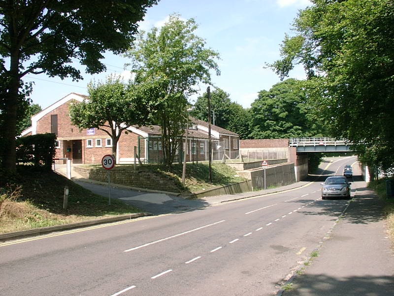 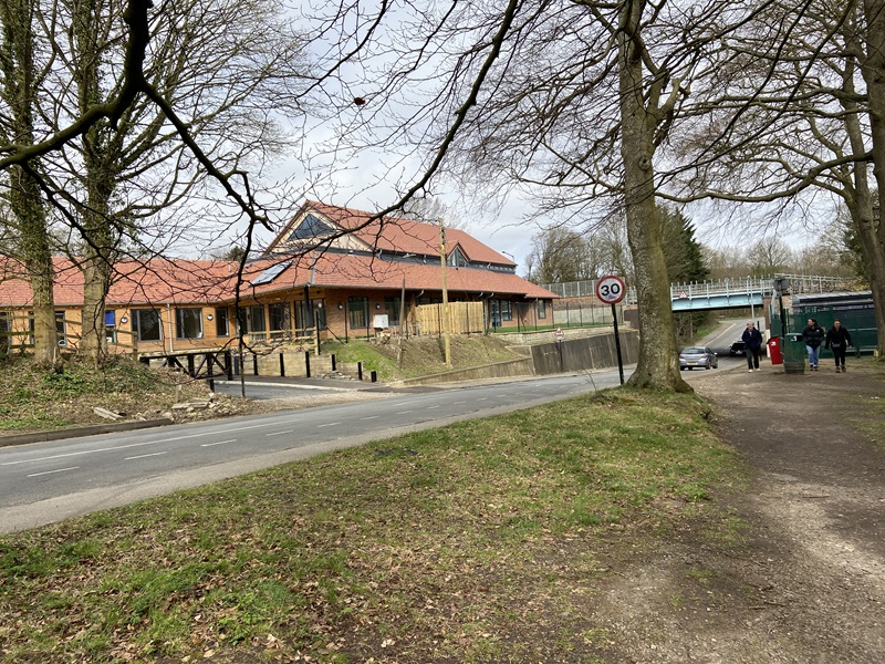 At the top of Rectory was a scout Hall. Around 2020 the hall was redeveloped to create a much improved facility. The first picture is from 2005, the second picture 2020 |
|
White Lion Road 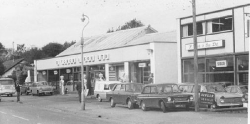 Photographs courtesy of Malcolm Flack For many years the site of H Flack and Son's Garage on White Lion Road, close to Black Horse Bridge, was a familiar site. The cars and garage changed over the years as the photographs from 1934 (left) and 1972 show. For more details of how Flacks and other garages changed in Amersham, see the Amersham Garages page. 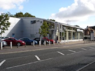 Photograph courtesy of Malcolm Flack The same site now is home to Amersham Audi. |
|
  The above photograph on the left shows the flats on White Lion Road taken in the late 1970's. In the 1990's they were refurbished to give them a softer more human look, shown in the photograph on the right. |
|
  The above photographs show views of the bus garage in Amersham Old Town. Left, the bus garage viewed in early 1960's and right, the side of the bus garage probably from the 1980's. As can hopefully be seen, the bus garage and associated offices on the right hand side (facing) were quite a large building. It was a classic 1930's design. The bus garage was closed in April 1992 and then demolished to make way for a new Tesco petrol station.   Above left in 2009, the entrance to Tesco, the petrol station of which occupies the site of the former bus garage. The entrance was the second entrance built for Tesco, made possible by the demolition of Fox's shop at the bottom of Gore Hill, seen in the poor quality photograph above right. A new shop for Fox's was built to replace the old shop, seen on the right in the above left photograph.   Another contrasting view of the bottom of Gore Hill. On the left a photograph from the 1970's showing Fox's and some houses beyond. A similar view on the right from 2020 shows the Tesco roundabout, new Fox's shop, now taken over by Mountain Warehouse, built on the site where the houses were. 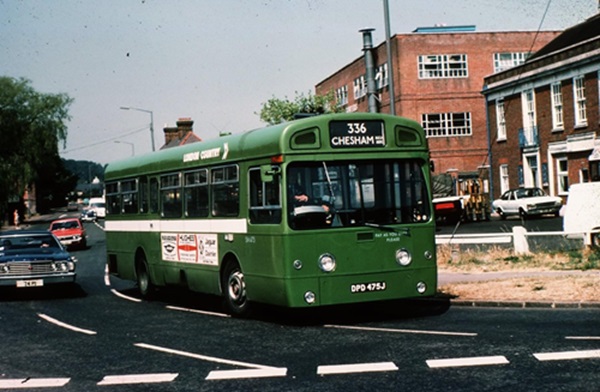 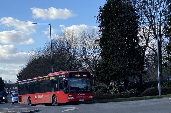 At the junction of London Road and Station Road, there used to be a meat / pie / sausage factory. Originally Brazil and later Bowyers. The first picture shows a bus to Chesham passing the location in the 1970s. The second picture shows the same location with a bus to Chesham passing what is now the end of Tesco's car park. |
|
  To the west of the old bus garage on The Broadway was B & M Motors. It actually occupied the original Amersham bus garage, which was replaced in the 1930s. The garage for many years had a Renault dealership and Toyota dealership and also a petrol station, which was one of the last places you could buy petrol and be served as opposed to having to do self service. The site was acquired by McCarthy & Stone who have built Chiltern Place, a block of retirement apartments, which opened in 2020. The left hand photograph shows B and M Garage during an Amersham Heritage Day event in the early 2000's, the right hand photograph is the same location in 2020.   Opposite the old Bus Station there used to be Market Garage. The photograph above left was taken in 1972, the photograph on the right of the same location is 2020.   Two similar views above from 1981 (left) and 2021 (right). The view has improved over the 40 years with the removal of the gas holders and the tall 1960's nursing home at the hospital, along with the hospital's laundry chimney and other buildings. |
Any additions, corrections, alterations, please email
the web master
Amersham Home Page
Amersham
This web site is Copyright
and operates a privacy
policy
Please also see disclaimer